Forty One Pounds…
I am amazed after
all the years I have lived in and visited Yosemite that I have never taken the
time to hike to North Dome. So on my
weekend I decided it was time to do so and make it my first overnight hike in
Yosemite since 1985, although I have logged hundreds of miles on the East Side
since 1985.
My trip started by
hitchhiking to the Porcupine Creek Trailhead and from there I would hike to
Indian Rock and end my day on North Dome making it an easy 5.5 mile hike. The
next morning I backtracked .5 miles and then took another trail to Yosemite
Point, then to the top of Yosemite Falls and hike down the falls trail back to
the valley.
In the past I always
tried my best to keep my pack around 35-40 pounds for a weekend backpacking
trip. On my way I stopped at the Wilderness Center and weighed my pack and it
was 41 pound. Not bad considering that I am carrying around 5 liters of water,
1 bottle of “Blue Goo” (my name for the blue Gatorade) and a partially frozen
Modelo beer, which will thaw by the time for lunch on North Dome.
It took only about 5
minutes of hitchhiking and I was picked up and driven all the way to Porcupine
Creek. After making a few adjustments to my pack off I went down the trail.
Here the trail starts out wide for the first .7 miles as it once was a road but
has been long since taken over by nature.
NOTE: ALL PHOTOS ARE TAKEN WITH JUST A POCKET CAMERA

The trail on an abandoned road
Not much further
down the trail you reach Porcupine Creek, which you make an easy traverse over
using a fallen tree.

Porcupine Creek

Porcupine Creek Log Crossing

After crossing the creek the trail becomes what most of that hike
are used to seeing, a narrow path wondering through the forest.
Soon I approached an area
of damp ground it was covered by bright green corn lilies.

Corn Lilies along the trail
A little further and
near another small runoff creek you come across an area laden with bright green
ferns.

Ferns covering the ground near a creek
At the 1.6 mile mark
on the trail as the great Yogi Berra once said, “I came to a fork in the road
and I took it”. The trail splits with the branch to the left heading to North Dome
and the Trail to the right heading to Yosemite Falls.

the "fork" in the road
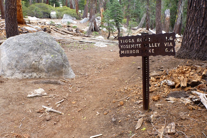
Tioga Road 1.6 miles away and where I started

the trail to the right...

And the trail to the left...I'm headed left...
From this point the
trail narrows and you begin a gradual climb toward Indian Rock and North Dome.
It is not very steep and more of a slight to moderate climb for about 1.3 miles

and climbing another trail
At this point you
reach the junction to Indian Rock a mere .3 miles away. The trail is all straight
uphill but well worth the short climb. Indian Rock is a natural arch but what
make is unique is it is made out of granite which is very rare given the
hardness of the rock.

Indian Rock with Sentinel Dome through
the window on the South Rim of the valley

Just liked the shot of this
tree at Indian Rock
After leaving Indian
Rock and rejoining the North Dome Trail you start to climb once more to the top
of and unnamed granite structure about .7 miles from the Indian Rock Trailhead.
At first you think you are climbing North Dome until you see it off in the
distance once your reach the top of this granite dome. Here you will find great
views and one or two camp spots with existing fire rings.

From where you "thought" was North Dome
only to see it a mile away in the distance
After enjoying the
view you head back down from your perch and the trail to North Dome winds
around the left side. The trail continues to drop as you make your way towards
your final destination. With .5 miles to go you reach yet another trail
junction. One headed toward the top Yosemite Falls 4.2 miles away and your
trail .5 miles to North Dome. It is a very steep, narrow and slick in places
and drops to the trees at the base of North Dome before you begin the short
descent to the top.

Made it....
North Dome has some
of the best views of the valley I have seen from any vantage point. From here
Half Dome looks only a stones throw away.

Half Dome
And Clouds Rest not
much further.

Clouds Rest
Looking from left to right from the same place on top of North Dome allows you a variety of views

Clouds Rest and Half Dome

Illouette Canyon and Illouette Falls

Glacier Point

Yosemite Valley from North Dome
After enjoying the 270 degree view it was time to relax and have lunch

not a bad place to have lunch...agreat view too...
Next it was time to
stretch out in my hammock, chill and take a siesta

just chillin'
After a short nap it
was time to evaluate the situation. First I thought I might just spend the
night here as it obviously had a great view and some protection. But looking at
the sky there was a possibility of thunderstorms and being on top of North Dome
is very exposed so I decided not to “break the rule” and descended back down to
tree line to make camp for the night.
In the tree line
there are three camp choices with existing fire rings. One is nothing special
so I contemplated over one that was well within the trees with great coverage
if it rained as I decided not to bring my tent. And the other was slightly more
exposed but with a much grander view even though they were only a couple
hundred yards apart.
I decided on the one
with the great view of Half Dome and began to set up came.

Camp2
After camp was set
up I walk part way up North Dome and took a couple of photographs of Clouds
Rest.

Clouds Rest
And of Half Dome
covered by the alpenglow

Half Dome drenched in Alpenglow
Next it was time to light
the fire and relax around camp

Not a bad view from the campfire
Though no bears
showed up during the night I was woken up several times by the deer that
continuously ventured very close to camp. The parade started about 10pm and
probably continued throughout the night. I’m not sure as after about a dozen
deer I was able to sleep through their stomping, bounding through the forest
and grazing. Upon arriving back I found out from the rangers there has been a
lot of bear activity in the area but I did see any at all. Which is good, as I
really didn’t want to have to deal with any bears in the middle of the night.
The next morning I
slept in until around 7am and broke camp. The first .5 miles is straight up
from the saddle near the base of North Dome where I spent the night to near the
top of the ridge.

From there the trail splits back the way I came or following
the north rim of the valley. I headed off taking the Rim Trail towards Yosemite
Point and the top of Yosemite Falls. The trail itself is
well defined and for the most part relatively flat or downhill without any
major switchbacks. It winds through the forest making it cool but also bringing
out the mosquitos. As long as you kept moving they were not that big of a
problem.

Hiking back up from North Dome
A little over half
way to the falls you start climbing again but it is not really steep you still
find yourself thinking you are at the top only to find you are at a false
summit and need to keep going. Over your shoulder every now and then you get a
glimpse of Half Dome and its surrounding mountaintops.

Going off trail to get a picture of Half Dome and North Dome
where I started this morning

A little further down trail gave yet another view...
this time of Half Dome and Indian Canyon
Finally reaching the
summit there are a number of places to take in the view. I headed to Yosemite
Point to get a couple pictures and relax after a few miles of hiking he trail.


Half Dome, Glacier Point and the Ahwahnee Hotel
from Yosemite Point

Glacier Point from Yosemite Point

The South Rim and Yosemite Valley
from Yosemite Point
It is not much
further continuing along the trail to the top of Yosemite Falls. The trail near
Yosemite Point can be a little confusing but watch for well placed “trail
ducks” and you should have no problem. You keep dropping into Yosemite Creek
Canyon taking one switchback after another. You can hear the stream and the
falls much sooner then you can see them. Once you find the stream you cross by
the uses of a wooden footbridge. DO NOT go swimming here even though it can
look relatively calm, doing so “breaks the rule” and a number of people have
been swept over the falls.
To get a look at the
falls you make a short climb out of the canyon and way from Yosemite Creek.
Reaching the top you find a trail marker pointing to the left for the Yosemite
Falls Overlook or you can go straight and begin the hike to the 3.2 mile
valley.
Opting for the
Overlook I took the short walk over a rise and down the steep steps towards the
falls. It is best to drop your pack at the top before heading down due to the
narrowness of the trail. At one point the trail hugs the cliff with one side
with a railing and the other a sheer drop. Once you reach the bottom there is
enough room to move about and get a few photographs. If you are afraid of
heights this descent is probably not for you.

The end of the trail and railing
to the Yosemite Falls Lookout

Yosemite Valley from the "Lookout"

And the Top of Yosemite Falls

And OVER the Falls...
Back from where the stairs take you to the Lookout I
relaxed drank some water, had a snack and enjoyed the view.

Next I threw my pack on and headed down the Yosemite Falls Trail. The trail is steep in parts and ranges from dirt to rock to slick rock covered with pea gravel and dirt making it very slick. This is my worse nightmare on the trail with my knees especially when carrying a 40 pound pack. I could remember back in the late twenties and early thirties when I used to really cover some distance and fly down the trail. Those days are all but gone as it took me close to three hours as I took my time being careful not to slip and injury myself any further as I am still nursing a dislocated shoulder from work about a month ago. Between my knees, shoulder and balancing a forty pound pack on your back it does not give you a lot of confidence going downhill on steep trails, so a slow go it is….

View from the top of the stairs
Next I threw my pack on and headed down the Yosemite Falls Trail. The trail is steep in parts and ranges from dirt to rock to slick rock covered with pea gravel and dirt making it very slick. This is my worse nightmare on the trail with my knees especially when carrying a 40 pound pack. I could remember back in the late twenties and early thirties when I used to really cover some distance and fly down the trail. Those days are all but gone as it took me close to three hours as I took my time being careful not to slip and injury myself any further as I am still nursing a dislocated shoulder from work about a month ago. Between my knees, shoulder and balancing a forty pound pack on your back it does not give you a lot of confidence going downhill on steep trails, so a slow go it is….
However it is well
worth it when you take a look around and see the valley below, Half Dome off in
the distance and Yosemite Falls at you side.

Headed down the Yosemite Falls Trail

Further down the Yosemite Falls Trail is a nice shot of Half Dome and of North Dome
peaking over the ridge giving perspective of where I started my hike this morning

Finally some views of Yosemite Falls


Even though the
trail drop close to 3,000 feet you still find yourself having to climb up the
trail in spots before again heading back down a few hundred feet. At the end of
the trail are the last sixty switchbacks. Some are short some or a bit long and
they seem to go on forever. You keep passing people with exhausted looks on
their faces knowing they still have two to three miles to go.
You might think that
going uphill is the tough part and it is but going downhill is even harder in
some ways. I always say “harder on your lungs going uphill and harder on your
knees and shoulders going downhill”. The bottom line is you pay the price on
way or another to enjoy the backcountry. And it is a price I am willing to pay
gladly….


